

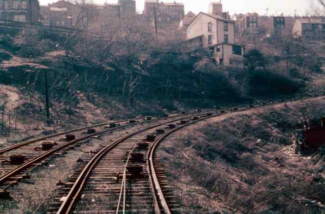
The Knoxville Incline was an inclined railway that ran between Pittsburgh's South Side and Knoxville neighborhoods. The incline was constructed in 1890, and was demolished in 1960. It had a track length of 2644 feet, and the Knoxville Incline featured a curve, an unusual engineering feat for an incline. The Knoxville Incline was operated by the Pittsburgh, Knoxville & St. Clair Electric Railroad, and later by Pittsburgh Railways. During its operation, the incline ferried people and freight between the South Side and Knoxville.
On October 7, 1953 a boy hanging from a car was killed. While it is reported that Pittsburgh inclines recorded no fatalities, this, along with an incident on the St. Clair Incline, provide the only marks on the safety record of inclines in Pittsburgh. None of the fatalities occurred with paying passengers who had not jumped from cars.

The bottom "landing" of the Knoxville Incline.
A view up the tracks...Check out the pulley system.

Here comes the car...Coming down the hill. This incline was so unique with the pass taking place in the curve.

Looking up the tracks from inside the car.

This was shot on the last day of operation, in 1960.
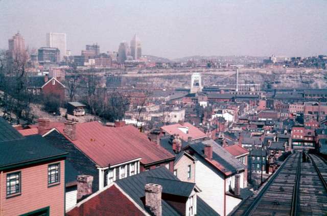
This is the track coming down the hill...Toward the landing. How different the skyline looks today!

This car is coming up through the curve...Awesome!

Bottom view of the upper station.

The other side of the upper station.

Knoxville Incline, lower station.

The Castle Shannon Incline was originally built in 1890 as part of the Pittsburgh and Castle Shannon Railroad as a means of transporting passenger traffic over Mt. Washington, rather than using the Pittsburgh and Castle Shannon Tunnel through Mt. Washington, which used a former coal mine. The mine continued to be used as a tunnel to transport coal to a separate incline that unloaded at a station on Carson Street. The incline ran from Bailey on Mt. Washington to Carson Street and Arlington. Its large cars were able to carry both passengers and automobiles. Originally steam powered, it was converted to electrical operation in 1918 by the Otis Elevator Company. Its track length was shorter than most, at 1,350 feet.
The incline was closed 21 June 1964. The former route of the incline is partly replaced by East Sycamore Street.

A snowy day but its still going!

You can see just how big the car were...Drive your car right on in there!

It is a forboding sight, to say the least.

Interesting shot, with the Smithfield St. Bridge in the background.

Awesome shot, with the newly constructed Civic Arena in the background. It was getting close to the end.

Old cars parked along Sycamore St.

The lower "station".

Bottom of the Castle Shannon Incline.

Top of the Castle Shannon Incline at Bailey St.

The Penn Incline, also known as the 17th Street Incline, was a funicular railroad that ran between the Strip and Hill districts in Pittsburgh, Pennsylvania. It operated from 1884 to 1953.
The incline ascended from 17th Street between Liberty and Penn avenues in the Strip District to Arcena (Ridgeway) Street near Ledlie Street in the Hill District. It measured 840 feet in length with a vertical rise of 330 feet. It was structurally massive, with over 750 tons of bridge work carrying the two 10-foot-gauge tracks over the Pennsylvania Railroad yards, Bigelow Boulevard, and Liberty Avenue.
A saloon and entertainment hall called the Penn Incline Resort existed for several years next to the upper landing. This resort, patterned after similar hilltop attractions in Cincinnati, was built together with the incline to boost business. It enjoyed early popularity and according to The Pittsburg Dispatch was "a favorite resort for the better class of Germans". With the implementation in 1888 of Pennsylvania's Brooks High License Law, the resort stopped selling liquor and went into decline. The building was destroyed in 1892 by a fire that spread from the incline's boiler house.
By the end of World War II, business was struggling. The incline was open only three hours in the morning and four hours in the afternoon when its last owner, Pittsburgh Railways, asked the state Public Utilities Commission permission to abandon it. Nobody opposed the request. The incline shut down on 30 November 1953 and within the next three years was dismantled.

Penn Incline operated from 1884-1953 and connected the Hill District to the Strip District, crossing over Bigelow Boulevard.

Another view of the Penn Incline.

View from the top of the Penn Incline.

The Nunnery Hill Incline was a funicular in Allegheny City, Pennsylvania, in what is now the Fineview neighborhood of Pittsburgh. Designed by Samuel Diescher, it operated from 1888 until 1895 between its base station on Federal Street to its upper station on the currently named Meadville Street. It was one of a few inclines with a curve in the track. The name of the hill derived from a short-lived settlement of Poor Clares earlier in the century.
The incline suspended operations without warning on 13 September 1895, to the consternation of many of the hill's residents. It did not resume business. By 1901, it was being dismantled.
Remnants of the incline, namely the red brick lower station and a stone retaining wall along Henderson Street, have been subject to preservation efforts. Both structures received City of Pittsburgh historic designations in 2011.

Nunnery Hill Incline was short-lived, only operating from 1887-1899. Connected Federal Street at Henderson Street to Meadville Street. It was the first incline to have a curved track.

Bellevue Incline 1887 1892
Castle Shannon Incline 1890 1964 South Shore:
Carson Street near Arlington Avenue Mount Washington: Bailey Avenue near Haberman
Avenue Pittsburgh Railways (Pittsburgh and Castle Shannon Railroad)
Castle Shannon Incline No. 2
1892 1914 Mount Washington: Warrington Avenue west of Haberman Avenue Mount
Washington: Bailey Avenue west of Haberman Avenue Pittsburgh Railways (Pittsburgh
and Castle Shannon Railroad)
Clifton Incline 1889 1905 Perry Hilltop: Strauss
Street near Metcalf Street Perry Hilltop: Irwin Avenue near Chautauqua Street
Clifton Avenue Incline Plane Company
Duquesne Incline 1877 — South Shore: Carson
Street Mount Washington: Grandview Avenue near Oneida Place Duquesne Incline
Plane Company
Now Society for the Preservation of the Duquesne Heights Incline
Fort Pitt Incline 1882 1900 Bluff: Second Avenue
near Tenth Street Bridge Bluff: Bluff Street near Magee Street Fort Pitt Incline
Plane Company
Knoxville Incline 1890 1960 South Side Flats:
Bradish Street between 11th and 12th Streets Allentown: Brosville Street near
Warrington Avenue Pittsburgh Railways (Pittsburgh Incline Plane Company)
Monongahela Incline 1870 — South Shore:
Carson Street near Smithfield Street Bridge Mount Washington: Grandview Avenue
near Wyoming Street Monongahela Incline Plane Company
Now Port Authority of Allegheny County
Monongahela Freight Incline 1884 1935 South Shore:
Carson Street near Smithfield Street Bridge Mount Washington: Grandview Avenue
near Wyoming Street Monongahela Incline Plane Company
Pittsburgh and Castle Shannon Plane before 1864
c. 1912 Carson Street Bailey Pittsburgh Coal Company
Mount Oliver Incline 1872 1951 South Side Flats:
Freyburg Street near 12th Street South Side Slopes: Warrington Avenue near
Mount Oliver Street Pittsburgh Railways (Mount Oliver Incline Railway)
Norwood Incline 1901 1923 Island Avenue Norwood
Place
Nunnery Hill Incline 1888 1895 Fineview: Federal
Street near Henderson Street Fineview: Meadville Street near Catoma Street
Nunnery Hill Incline Plane Company
Penn Incline 1884 1953 Strip District: Spring
Way near 17th Street Hill District: Arcena Street near Ledlie Street Pittsburgh
Railways (Seventeenth Street Incline Plane Company)
Ridgewood Incline 1886 1887 Perry Hilltop: North
Charles Street near Nublock Street Perry Hilltop: Yale Street near Ridgewood
Street Ridgewood Incline Plane Company
St. Clair Incline 1888 1932 South Side Flats:
Josephine Street near Greeley Street South Side Slopes: Salisbury Street between
Fernleaf and Sterling Streets St. Clair Incline Plane Company
Troy Hill Incline 1888 1898 Troy Hill: Ohio Street
Troy Hill: Lowrie Street near Froman Street Troy Hill Incline Plane Company
More to Come!
![]()